Couderay's Historical Markers
Early Logging Industry
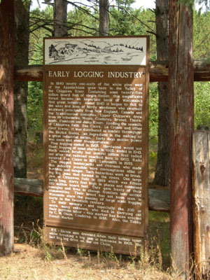
Located near Eddy Creek, this marker reads:
In 1840 nearly one-sixth of the white pine west of the Appalachians grew here in the Valley of the Chippewa River. Containing some twenty-five billion board feet of virgin timber. This magnificent forest became an important basis of Wisconsin's first great industry. About 1840 it began to fall to the axes and saws of hardy woodsmen who swarmed westward principally from New England, Canada and the Scandanavian countries. Upper Chippewa drew from its tributaries, Moose, Couderay, Brunet, Thornapple, Flambeau and Jump Rivers. Feeding the sawmills of Chippewa Falls, Eau Claire, La Crosse and other river towns. It was distributed as lumber throughout the United States, an ingredient in the making of a great industrial nation. Early days motive power was oxen and river transportation.
Pine logging ended in 1905. Hardwood would not float; logging of same started in 1885, ended in 1945. Much sawed locally but several billion feet railed out after the railroad reached here in 1903. Rails entered Eau Claire in 1871, Ladysmith in 1885.
The rugged lumberjacks and rivermen who made this industry possible were contemptuous alike of hardship and danger. Such hazardous work as breaking log jams that formed in the rivers. One large jam at Chippewa Falls in 1869 which was fifteen miles long, thirty feet high in places and contained 150 million board feet. They gave freely of their energies and lives to change frontiers into settled communities. Their breed has not been seen in Wisconsin since the passing of large scale logging early in the twentieth century.
To their memory - and especially the 200 or more, many unknown, who died in carrying out their perilous labor - this marker has been erected by C.M. Olson, Couderay, in 1956. Also, the Tubby Forest Marker.
P.S. - Eleven men drowned when their bateau upset while breaking a log jam at Holcombe in 1905, the last big log drive on the old Chipp.
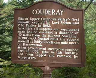
Couderay
Located near Eddy Creek, this marker reads:
Site of Upper Chippewa Valley's first sawmill; erected by Levi Felton and P.M. Parker in 1902.
In winter all supplies and equipment were hauled overland a distance of 40 miles from the nearest Soo Line. In 1903 A.O. Nustad built the second sawmill at Eddy Creek one mile north on Reservation.
When government surveyors reached here in 1856, pine in this locality had been logged and removed by trespassers. Erected 1960 by C.M. Olson
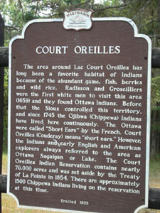
Court Oreilles
Located near east edge of town, this marker reads:
The area around Lac Court Oreilles has long been a favorite habitat of Indians because of the abundant game, fish, berries and wild rice. Radisson and Groseilliers were the first white men to visit this area (1659) and they found Ottawa Indians. Before that the Sioux controlled this territory, and since 1745 the Ojibwa (Chippewa) Indians have lived here continuously. The Ottawa were called "Short Ears" by the French. Court Oreilles (Couderay) means "short ears." However, the Indians and early English and American explorers always referred to the area as Ottawa Sagaigan or Lake. The Court Oreilles Indian Reservation contains nearly 70,000 acres and was set aside by the Treaty of La Pointe in 1854. There are approximately 1500 Chippewa Indians living on the reservation at this time.
Erected 1955
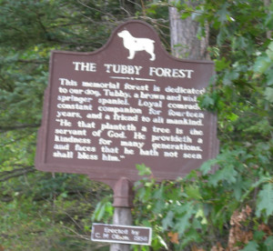
Tubby Forest
Located near east edge of town, this marker reads:
This memorial forest is dedicated to our dog, Tubby, a a brown and white springer spaniel. Loyal comrade, constant companion for fourteen years, and a friend to all mankind. "He that planteth a tree is the servant of God. He provideth a kindness for many generations, and faces that he hath not seen shall bless him.
Erected by C.M. Olson, 1956